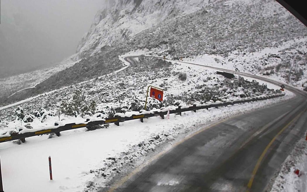
Snow around the Homer Tunnel in Fiordland (file). Photo: Supplied
峡湾地区荷马隧道周围的积雪(档案)。 照片:提供
Snow, wind and rain warnings have been issued as a cold easterly front develops across the motu with wild weather forecast until Wednesday.
【澳纽网编译】随着一股寒冷的东风锋面横扫南岛,已经发布了降雪、大风和降雨警告,预计恶劣天气将持续到周三。
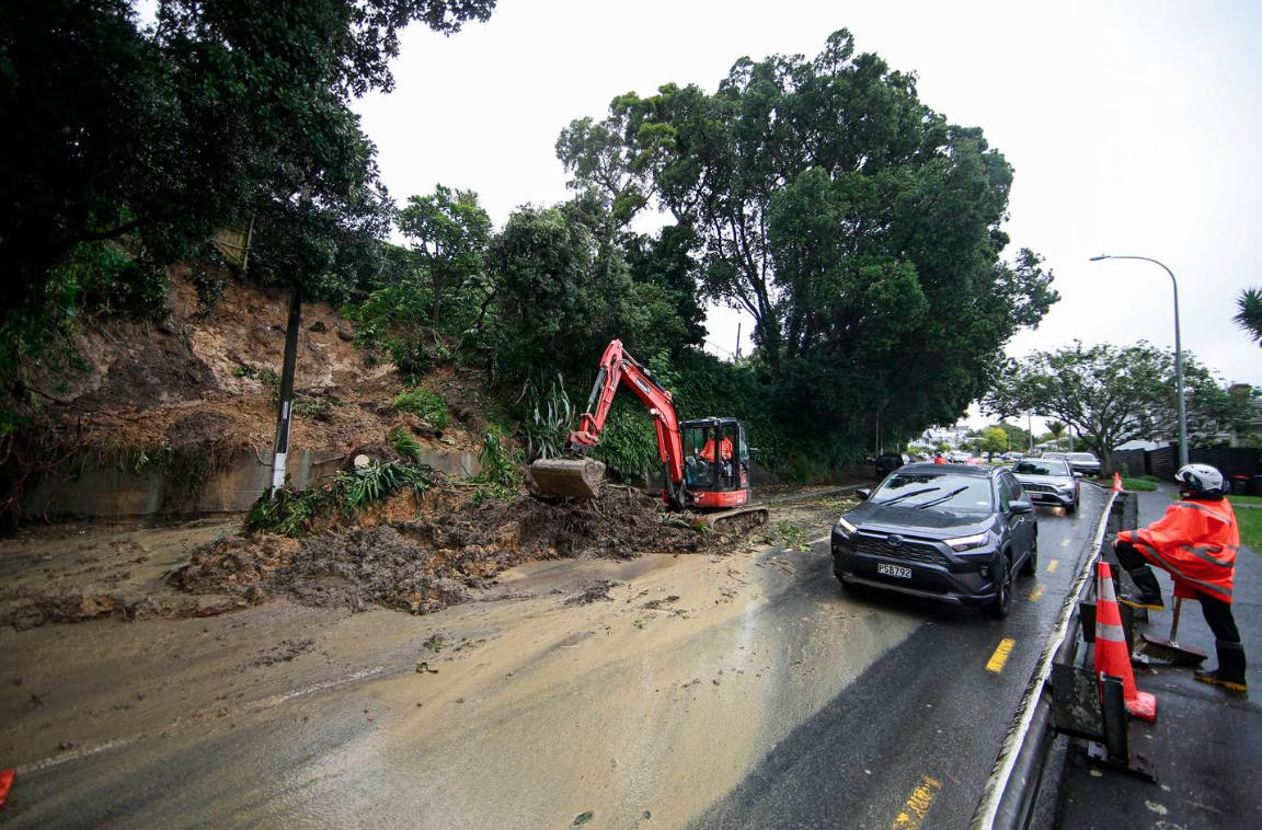
An orange heavy rain warning is in force for North Otago, Dunedin, Clutha and northern Tasman with up to 100mm of rain expected to fall, causing MetService to warn of streams and rivers potentially rising rapidly.
奥塔哥北部、但尼丁、克鲁萨和塔斯曼北部的橙色暴雨警告已经生效,预计降雨量将达到 100 毫米,导致 MetService 警告溪流和河流可能迅速上涨。
广告 | Advertisement
在澳纽网做广告 | Advertise with us
Inland parts of Otago and the South Canterbury High Country are also under heavy snow warnings, with up to 35cm likely to fall above 400m. Snow warnings are in place for most high level roads in the South Island.
奥塔哥和南坎特伯雷高地的内陆地区也受到大雪警告,最高可达35厘米,雪线400米。南岛的大多数高等级道路都发布了积雪警告。
MetService said travel disruption is possible, as is damage to trees and powerlines.
MetService表示,旅行中断是可能的,树木和电力线的损坏也是如此。
“If you must travel, drive cautiously, and ensure you have snow chains, sleeping bags, warm clothing, and emergency items,” it said in a statement.
“如果你必须旅行,请谨慎驾驶,并确保你有防滑链、睡袋、保暖衣物和应急物品,”它在一份声明中说。
Wind gusts in Westland and Fiordland may reach 120km/h on Tuesday and Wednesday, and both regions are under an orange strong wind warning.
周二和周三,西地和峡湾地区的阵风可能达到120公里/小时,这两个地区都处于橙色强风警告之下。
广告 | Advertisement
在澳纽网做广告 | Advertise with us
High sided vehicles and motorbikes were warned to take extra care driving in these conditions and people should secure items on their property that might be at risk of being blown away, MetService said.
MetService表示,高边车辆和摩托车被警告在这些条件下驾驶时要格外小心,人们应该在他们的财产上保护可能有被吹走风险的物品。
Road snowfall warnings are in place for:
道路降雪警告已到位:
- Lewis Pass (SH7) 刘易斯隘口 (SH7)
- Arthur’s Pass (SH73) 亚瑟隘口 (SH73)
- Porters Pass (SH73) 搬运工隘口(SH73)
- Lindis Pass (SH8) 林迪斯隘口(SH8)
- Crown Range Road 皇冠岭路
- Milford Road (SH94) 米尔福德路 (SH94)
- Dunedin to Waitati Highway (SH1)
但尼丁至怀塔蒂公路 (SH1)
A heavy snow watch is also in place for North Canterbury high country and the foothills north of the Rangitata River and inland areas of Otago and Southland, as well as eastern Fiordland.
北坎特伯雷高地和朗伊塔塔河以北的山麓、奥塔哥和南部地区的内陆地区以及峡湾地区东部也发布了大雪预警。
Rain watches are also in place for Bay of Plenty, Taranaki, Marlborough, Canterbury, Westland and Southland.
丰盛湾、塔拉纳基、马尔堡、坎特伯雷、西地和南部地区也发布了大雨预警。
广告
Advertise with us
MetService meteorologist Lewis Ferris said a large weather system is bringing a lot of rain to eastern Southland in particular, along with a risk of widespread snow in the southern parts of the South Island.
气象服务气象学家刘易斯·费里斯(Lewis Ferris)表示,一个大型天气系统正在给南部地区东部带来大量降雨,同时南岛南部地区也有大面积降雪的风险。
“With the system moving in it is bringing in that rain first, however we have already seen some snow already turning up at Homer Tunnel, though that is quite elevated,” Ferris said.
费里斯说:”随着系统的移动,首先带来的是降雨,不过我们已经看到荷马隧道已经出现了一些积雪,不过积雪高度较高。
“It is through into Tuesday that we expect that snow to fall lower as cooler air moves in and that will affect southern parts of the South Island.”
“预计到周二,随着冷空气的进入,雪线会更低,这将影响南岛南部地区”。
Meanwhile, there is also a strong wind warning for the central North Island, with drivers of lighter or high-sided vehicles and motorcycle riders between Rangipo and Waiouru advised to take extra care.
同时,北岛中部还发布了强风警告,建议兰吉波和怀乌鲁之间的轻型或高边车辆驾驶员和摩托车骑手格外小心。
来源:RNZ
广告 | Advertisement
在澳纽网做广告 | Advertise with us

MetService is forecasting 18 to 33 hours of heavy snowfall in some areas.
MetService预测,一些地区将有18至33小时的大雪。

Parts of the South Island are due to be battered by heavy rain and snowfall.
南岛的部分地区将受到大雨和降雪的袭击。
METSERVICE 气象服务
Aucklanders can expect Monday to be a day of two halves, getting wetter as the day goes on.
奥克兰人预计周一将有两个半天,随着时间的推移会变得更加潮湿。
“It won’t be so bad on the bike ride into school, but there’ll be isolated showers in the afternoon,” MetService forecaster Gerard Bellam told Stuff on Sunday.
“骑自行车上学不会那么糟糕,但下午会有孤立的阵雨,”MetService预报员Gerard Bellam周日告诉Stuff。
A high of 16C and a low of 12C can be expected in Tāmaki Makaurau.
预计 奥克兰的最高气温为 16 摄氏度,最低气温为 12 摄氏度。
Those in the capitalwill see showers before dawn and rain developing into the afternoon.
那些在首都的人将在黎明前看到阵雨,雨水会发展到下午。
A high of 14C and a low of 11C are forecast for Wellington, which is “a few degrees above average for this time of year”, Bellam said.
贝拉姆说,预计惠灵顿的最高气温为14摄氏度,最低气温为11摄氏度,“比每年这个时候的平均水平高出几度”。
分类: 澳纽资讯
(即时多来源) 新西兰英语新闻 New Zealand English News

广告 | Advertisement
在澳纽网做广告 | Advertise with us
843 views